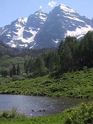
The classic view from Maroon Lake
(taken after the climb)
|
Ringing Both Bells
By Warren Teissier
(warra@comcast.net)
Photos by George Bell
(gibell@comcast.net)
Written June 2003; Climb date 6/21/2003
[Click on any image for the full size version]
|
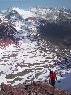
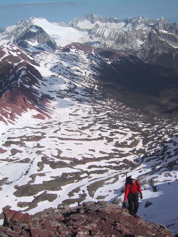
Warren nearing the summit of South Maroon.
Snowmass and Capitol behind.
|
|
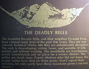
The Maroon Bells warning sign
Copyright © 2003 by
George I. Bell
|
After nearly twelve hours on the move George and I stopped at the trailhead close to our
car at the Maroon lake parking lot and got to read the "Deadly Bells" message posted by
the National Forest administrators.
As we were finished reading, a gentleman approached us and after inquiring our ascent
route told us he and his climbing party had once been flushed out of the same route by an
avalanche… Luckily no one had been hurt.
Whew! I am glad I didn't get to read this or talk to this guy at 4 am when we were
starting the climb!
George and I had talked about completing the Maroon Bells traverse about a year ago.
We picked June 21st as the target date, the onset of summer and the longest day of the
year. This endeavor would have us ascend the Bell Cord Couloir that splits both Bells,
take a left turn to summit Maroon Peak then head back and across the half a mile
connecting ridge to North Maroon's summit. We would then descent the "North West or
Gunsight ridge" a route described as straightforward by Gerry Roach's guide book.
Three days before the climb I went to Breckenridge with the family to enjoy some early
summer weather in the mountains. Instead, we got three days of rain and thunderstorms.
It wasn't looking good when George and I met in Frisco on Friday afternoon and drove to
Aspen. But the weather man insisted Saturday would be sunny and dry. As we crossed
Independence Pass (12,000 ft) at 8pm it was snowing…
|
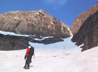
In the wide part of the Bell Cord Couloir.
Copyright © 2003 by
George I. Bell
|
George found an obscure trailhead he remembered from 10 years ago and we set up camp
for the night. I quickly passed out in spite of the arrival of a car full of barking dogs. We
went to be at 10:30 pm and set our alarms for a 3:00 am start. Sometime around midnight
George heard the pitter patter of rain on the tent fly and spent the next hour thinking we
would have to bag the climb and considering other possible hikes/climbs in the area.
At 3:00 am George opened the tent to reveal a clear sky studded with stars. By 4:10am
we were starting up the trail. I had forgotten my head lamp and George had forgotten his
gaiters, Team Gumby was on the move.
As we reached the talus field at the base of the Bell Cord couloir we spotted three
climbers starting up. After a while, one of them retreated and the race to reel-in the other
two was on. The snow was really hard and we made good progress cramponing as fast as
our lungs allowed. We worked our way through a maze of runnels and Bergshrunds up
the couloir and caught up with them before the couloir narrowed. They were two
climbers from Colorado Springs and they seemed happy to let us go through and break
trail for them.
|
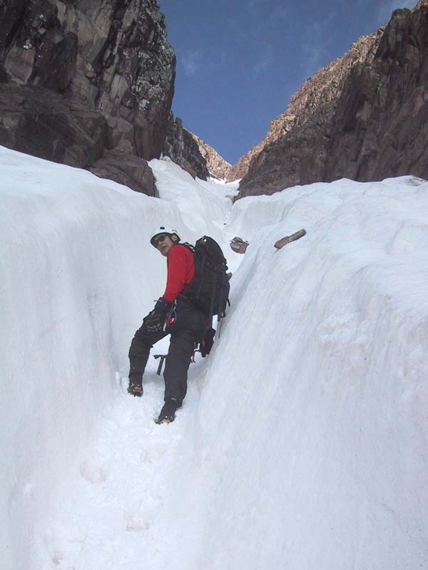
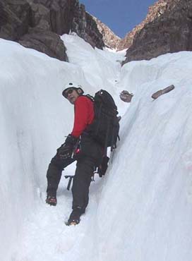
Warren in the runnel at the narrowest point.
Note rocks on top of the snow.
Copyright © 2003 by
George I. Bell
|
At the spot where the couloir narrowed, there was no choice but to go into the runnel,
something we had tried to avoid since runnels serve as funnels for falling rocks and
chunks of ice. It was getting real warm since the sun was reflecting into the narrow
runnel. The snow got softer and started to ball up in our crampons. George plowed ahead
for a while eventually offering me the opportunity to break trail. I moved to the front and
promptly understood the difference between kicking in steps and following steps. It took
three good kicks per foot to consolidate the snow at each step. As I started to fade, we got
to the narrowest section of the couloir, about ten feet wide, and noticed water falls
trickling down the rocks with the occasional sound of ice falling and some rocks for good
measure. This was the incentive I needed to get moving. We "powered" out of the runnel
and past a couple of other shooting galleries. George took over the lead again just as the
Colorado Springs guys behind us yelled: rock! A football sized rock tumbling down the
couloir missed the lower one of the two by a couple of feet. It was time to get out of the
shooting gallery.
The Couloir ends at 13,780ft two thousand feet above the starting talus field. We
removed our crampons and stashed some water for our return on the traverse. We greeted
the guys from the springs as we looked for the start of the climb to Maroon Peak. The
book said to start left but this seemed harder and had verglas on most of the key holds. So
we went right. This turned out to be easier. We were now ascending the North face of
Maroon Peak. We had 400 vertical feet to go, up loose third class ledges that were
randomly covered with verglas patches. It was slow, careful, going. There were some
large snow fields that made the route hard to sort out but we eventually reached the
summit only to find a large snow patch partially covering the top under which we
assumed was the register. We ate and took some pictures and by 9:20am we started the
traverse to North Maroon.
From where we stood the traverse did not look hard, but as I looked at the ground I was
walking I realized it would be harder than it looked. Due to the loose rock, ice patches,
the constant need to bring out the ice axes to cross snow gullies, and the snow covered
cairns it took us two hours to cover half a mile of ground, roping up once to climb one of
the rock steps. The views and exposure from the ridge are simply amazing. Based on the
guidebook's description we expected the toughest pitch to come near the end of the
traverse and indeed from afar it seemed a band of cliffs would block our access to the
summit. But George navigated us masterfully and found an easy way up the bands. By
11:20am we were signing the North Maroon summit register.
|
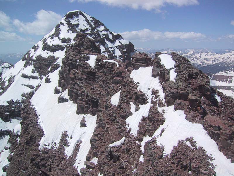
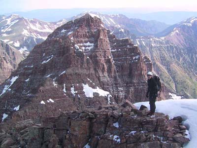
Looking towards North Maroon from South Maroon.
Copyright © 2003 by
George I. Bell
|
A quick look down the NE ridge route, the standard route up north Maroon, revealed a
ton of snow with no tracks. We had no choice but to descent the Gunsight route as
planned. We expected an easy stroll down to the Gunsight couloir. We were tired having
climbed over 5,000 vertical ft and spent 3 hrs traversing at nearly 14,000 ft. The
straightforward descent route was not to be. We had trouble finding cairns (they were
probably covered by snow) and the guidebook descriptions were short and vague. We
wandered down, picking our way between loose gullies and rock steps on the ridge,
hoping not to get cliffed out. Eventually, we had to cross a fairly steep snowfield that
seemed to end at a cliff from where the beautiful plateau extending to Snowmass
mountain was visible some 2,000 ft below. Out came the axes and with much trepidation
on my part we crossed it.
The snow in upper 200 ft of the Gunsight couloir had already melted so we were required
to do two single rope rappels. From there we once again moved into the snow and
plunged down in long steps to the cirque at the base of the North Face of North Maroon
Peak. We still had 4,500ft in altitude to lose.
We hiked the snow fields avoiding as best we could the avalanche debris and followed a
climber's trail that now doubled as drainage for the melting snow. Finally, some four
hours and 5 miles after starting our descent we reached the cars. What a great day:
Awesome mountains, awesome routes, perfect weather and in great company.
|
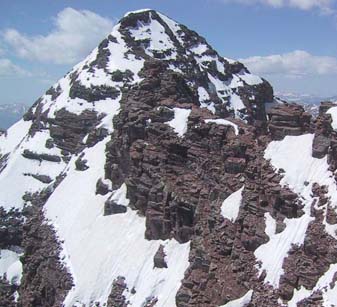
Looking towards South Maroon from North Maroon.
Copyright © 2003 by
George I. Bell
|
A guy with a fishing rod walked by us in the parking lot as we were getting out of our
boots and asked which mountain we had climbed, I told him we had done both of the
Maroon Bells, he nodded smiling and asked if we had made it to the top. I smiled in turn
and said yes. Had I known you could CLIMB both without summiting, I may have given
it some consideration.
 Trip Report Index ...